Article Summary
- NDVI measures plant health by analyzing how crops reflect red and near-infrared light, allowing early stress detection.
- Drone scouting with NDVI provides a fast and detailed overview of fields, making it easier to target problem areas.
- NDVI helps farmers catch diseases like southern rust early, enabling timely intervention and better yield protection.
- Farmers can save on inputs by applying treatments only where necessary based on NDVI insights.
- Integrating NDVI into farming practices enhances decision-making, ensuring timely responses to crop stress.
Out here in the Midwest, farmers have always relied on boots, eyes, and a lifetime of experience to keep crops on track. But these days, with fields stretching farther and input costs rising, it pays to have tools that can see what we can’t. That’s where drone scouting with NDVI has become one of the most valuable tools on the farm.
I know that NDVI sounds like something cooked up in a university lab—and it was—but the idea behind it is simple: measure plant health by how crops reflect light. And once you understand how it works, you may wonder how you got by without it.
Enabled by Multispectral Photography
In the past, farmers who were interested in aerial crop scouting relied on expensive subscriptions to low-resolution (and expensive) satellite images. Today, similar abilities are available on affordable drones that carry unique cameras. Multispectral digital cameras can capture “Red-Edge” and “Near-Infrared” wavelengths of light that allows us to “see” things we cannot otherwise see as humans.
🌱 What NDVI Really Means
ok. Sorry. We need a little bit of science-like talk here…
Like all plant health indexes, NDVI applies math against the values of certain color channels of a digital image. NDVI stands for Normalized Difference Vegetation Index. It’s a way of measuring how “alive and kicking” your plants are by comparing two kinds of light:
- Red light — healthy plants absorb it for photosynthesis
- Near‑infrared (NIR) light — healthy plants reflect it
The NDVI formula looks like this:
I think that it’s super cool that this comes down to pretty simple math! You don’t need to memorize the formula, or even remember how to solve it… Just know this:
- High NDVI (a result closer to +1) = healthy, vigorous plants
- Low NDVI = stressed plants (disease, drought, nutrient issues, compaction, insects—you name it)
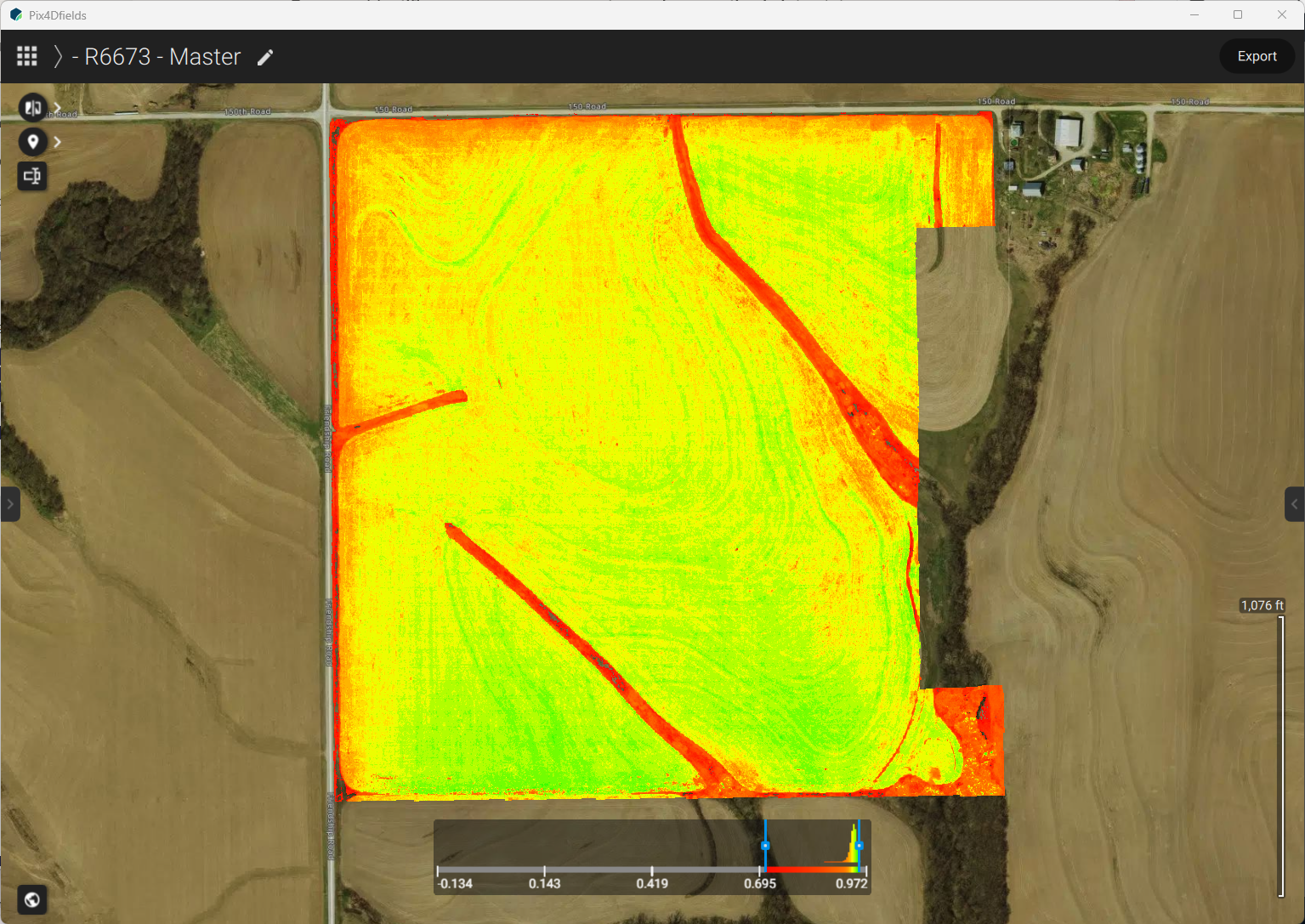
NDVI maps turn these numbers into colors. Greens mean good. Yellows and reds mean trouble. Take a look at this comparison between true-color (left) and NDVI (right). Slide the control to explore the change.


Here’s the kicker: NDVI picks up stress long before your eyes can see it. If you were driving by this field, it would look great! Until you evaluate NDVI and see the perimeter is stressed (red), and big parts of the field are starting to stress (yellow). This is why NDVI has become the backbone of modern drone crop scouting.
🚁 Why Drone Crop Scouting is Changing the Game
Walking a field still matters. But walking 80 acres in July heat isn’t exactly efficient, and you’re only seeing a tiny slice of the whole picture. Meanwhile:
- A drone can scout 100 acres in 40 minutes. And do it in detail.
- NDVI maps expose the plants that are invisibly calling for help.
That’s the power of aerial crop scouting: you get a bird’s‑eye view of the entire field, and NDVI tells you exactly where the trouble areas are that deserve a visit with your boots on. Instead of wandering around hoping to spot something, you walk straight to the problem areas. That saves time, saves inputs, and protects yield.
🌾 Southern Rust: Why It Shows Up at Field Edges First
If you grow corn, you know southern rust is no joke. It blows up from the south every year, and when conditions line up—heat, humidity, and a little bad luck—it can explode fast, as it did in 2025.
One thing many farmers notice is that southern rust and other fungal diseases often show up first at the edges of fields. There’s a simple reason:
✈️ Aerial fungicide applications often miss the outer rows
When planes or helicopters spray fungicide, they pull up at the field edges. That means the borders don’t always get full coverage. Even a small gap in protection is enough for rust or other fungi to get established.
Once southern rust grabs hold at the edges, it moves inward quickly. By the time you see orange pustules with your own eyes, you’re already behind.
🌱 NDVI catches it early
Because NDVI detects subtle stress changes, it can flag those edge problems days or even weeks before symptoms show up visually.
A typical NDVI map will show:
- A yellow or orange band around the field perimeter
- Irregular stress patches where disease or moisture issues are starting
- Hotspots that deserve immediate boots‑on‑the‑ground scouting
This early warning is exactly why drone scouting has become a must‑have tool for corn growers.
🌦️ NDVI Helps You Act Before Problems Spread
Here’s what NDVI brings to the table:
✔ Early disease detection
NDVI highlights stress patterns that match early fungal infection—before you can see it.
✔ Targeted scouting
Instead of walking the whole field, you walk straight to the hotspots.
✔ Better fungicide timing
You spray before the disease takes off, not after.
✔ Input savings
You treat only where needed instead of blanket‑spraying.
✔ Yield protection
Catching southern rust early can save serious bushels.
✔ Historical tracking
You can compare NDVI maps week‑to‑week or year‑to‑year to understand trends.
✔ Precision agriculture integration
NDVI layers plug right into variable‑rate prescriptions for nitrogen, fungicide, and irrigation.
🚜 The Bottom Line
NDVI isn’t replacing any farmer’s instincts—it’s sharpening them. With drone crop scouting you get a detailed full‑field picture quickly, and NDVI shows you where the crop is hurting before you’d ever spot it from the ground.
When diseases like southern rust sneak in at the field edges—often because aerial applications don’t fully cover those borders—NDVI gives you the early warning you need to get ahead of it.
In farming, timing is everything. NDVI helps make sure you’re not a week late and a bushel short. Consider making regular use of a multispectral drone as part of your system of crop management.