Key Takeaways
- Integrating drone data with farm management software transforms agricultural practices by providing actionable insights and improving efficiency.
- Drones collect valuable data such as multispectral images, thermal readings, and crop health assessments essential for effective farm management.
- Choose compatible farm management software to ensure it handles drone data formats and offers cloud storage, mapping capabilities, and mobile access.
- To successfully integrate, organize existing farm data, establish collection protocols, and train your team on how to use the system.
- Farmers who integrate drone data report better problem detection, cost reductions in inputs, improved record keeping, and enhanced decision-making.
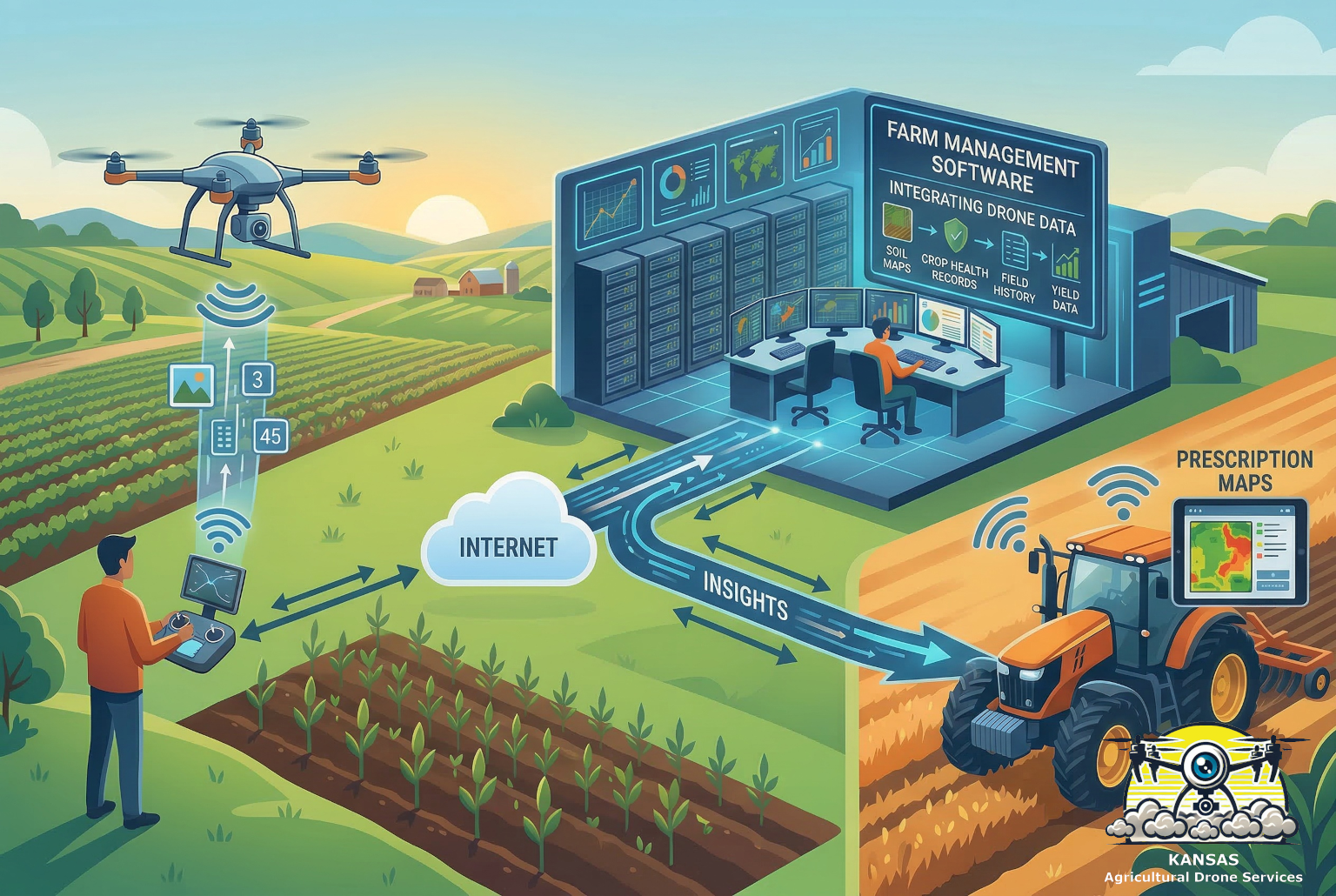
Think about it, your drone is similar to having a really smart scout that can cover hundreds of acres in minutes. But without connecting that information to your existing farm records, you’re missing out on the bigger picture. When you merge your drone data with your management software, you’re creating a powerful system that tracks everything from soil conditions to crop health in one place, multiplying the power of any analysis available on that platform.
What Drone Data Actually Provides
Modern agricultural drones collect way more than just pretty pictures. These flying workhorses gather detailed information that can transform how you manage your fields. The most common types of data include:
- Multispectral images that show plant health and stress levels
- Thermal readings that identify irrigation problems
- Precise field mapping with GPS coordinates
- Crop emergence and stand counts for planning decisions
- Pest and disease detection before problems spread
The real magic happens when this data gets organized and stored in a way that provides other insight about your operations. Raw drone footage might show you there’s a problem in the north forty but comparing that to the other data you collect tells you exactly where, what kind of problem, and how it compares to last season.

According to the USDA’s agricultural technology initiatives, farms using integrated drone and software systems report 15-20% improvements in input efficiency and yield optimization.
Choosing the Right Farm Management Software
You have likely already selected farm management software based on issues not related to integrating drone data. Not all farm management software plays nice with drone data. If you’re open to changing your software, you’ll want to look for platforms that can handle the specific file formats and data types produced by the drones working hard over your fields. The best systems offer:

Cloud-based storage that can handle large image files without slowing down your computer. Drone flights can generate gigabytes of data, and you need somewhere reliable to store it all.
Mapping capabilities that turn your drone images into actionable field maps. Look for software that can overlay drone data onto your existing field boundaries and create zones based on what the drone sees.
Data analysis tools that can spot trends and patterns you might miss. The software should be able to compare current conditions to historical data and flag areas that need attention.
Mobile access so you can check on your fields from anywhere. Whether you’re at the coffee shop or standing in the field, you should be able to pull up your drone data on your phone or tablet.
Popular options include platforms like Climate FieldView, Granular, and AgriWebb, and of course John Deere Operations Center though the best choice depends on your specific farming operation and the types of drones you’re using.
First Step to Integrating your Drone Data
Getting your drones talking to your farm management software doesn’t have to be rocket science, but it does require some planning. Here’s how most farmers tackle the setup:

Start with your existing data. Before adding drone information, make sure your current farm records are organized and up to date. This effort may take you a very long while if you do not use the platform very much, but the effort will pay off. The information includes field boundaries, soil test results, planting records, and harvest data. Your drone data will be most valuable when it can be compared to this historical information.
Establish data collection protocols. Decide when and how often you’ll fly your drones over each field. Many farmers find that weekly flights during growing season provide enough data without being overwhelming. Create a schedule that makes sense for your crops and growing conditions.
Set up automatic uploads. The best systems let your drone data flow directly into your management software without manual file transfers. This might mean connecting your drone’s memory card to a computer that automatically uploads images, or using drones that can transmit data directly to the cloud.
Train your team. Make sure everyone who needs to access the integrated data knows how to use the system. This includes family members, hired help, and any consultants or advisors who work with your operation. Be wary of the number of people with access as more users = more opportunity for data loss.
Be safe! There are unscrupulous people in the world. Protect yourself and your data. Ensure you are careful with your login credentials and limit access to your data.
Pilot certification. You may also want to explore The steps to becoming an Agricultural Spray Drone Pilot in Kansas for specialized training if you plan on owning your drone in the future.
Making Sense of All That Information
Once your drone data starts flowing into your management software, you’ll have more information about your fields than ever before. The trick is learning how to use it effectively without getting overwhelmed.
Start by focusing on actionable insights rather than trying to analyze every detail. Start small and plan ahead, even as you are cleaning up your existing data. Look for patterns that suggest specific problems or opportunities. For example, if your drone consistently shows stress in the same area of a field, you might have a drainage issue or soil compaction problem.
Create custom alerts that notify you when conditions change. Many farm management platforms can automatically flag areas that show sudden changes in plant health or growth rates. This lets you address problems quickly instead of waiting until they become obvious from the ground.
Use the data for input optimization. Drone information can help you apply fertilizer, pesticides, and water more precisely. Instead of treating entire fields uniformly, you can create application maps that adjust rates based on what your drone sees. For precise application, understanding Ways to measure what you’re putting down is crucial.
Research from Penn State Extension shows that farmers using integrated drone and software systems typically reduce input costs by 10-15% while maintaining or improving yields.
Real-World Benefits after you Merge Your Drone Data
Farmers who successfully integrate drone data with their management software consistently report several key benefits. These improvements often pay for the technology investment within just a few seasons.
Better problem detection is probably the most immediate advantage. Drone data can spot issues like pest infestations, nutrient deficiencies, or irrigation problems days or weeks before they become visible from ground level. This early warning system lets you take action before small problems become big ones.
More precise input applications can significantly reduce costs while improving results. When your management software combines drone data with soil test results and historical yield maps, it can create incredibly detailed application prescriptions that put inputs exactly where they’re needed most.
Improved record keeping makes it easier to track what works and what doesn’t. The integrated system automatically documents field conditions, treatment dates, and results, creating a detailed history that helps you make better decisions in future seasons.
Enhanced crop insurance documentation can be valuable when dealing with weather-related losses or other claims. Drone images provide detailed, timestamped evidence of field conditions that can support insurance claims or USDA program applications.
Overcoming Common Challenges
Like any new technology, integrating drone data with farm management software comes with some bumps in the road. Most problems are manageable once you know what to expect.
Data overload is probably the biggest issue most farmers face. It’s tempting to collect as much information as possible, but too much data can actually make decision-making harder. Focus on the metrics that directly impact your farming decisions, and don’t feel like you need to analyze every image in detail.
Weather limitations can disrupt your data collection schedule. Drones can’t fly in high winds or during precipitation, and cloudy conditions can affect image quality. Build some flexibility into your monitoring schedule and don’t panic if you miss a few planned flights.
Learning curve challenges are normal when adopting any new technology. Most farmers find it takes a full growing season to really understand how to use integrated drone and software systems effectively. Start with basic applications and gradually add more sophisticated analyses as you gain experience.
According to Purdue University’s Digital Agriculture Program, farmers who stick with integrated systems for at least two full seasons report much higher satisfaction and better return on investment than those who give up early.
Looking Toward the Future
The ease and ability of integrating drone data into your farm management software is getting smarter every year. Artificial intelligence and machine learning are starting to automate many of the analysis tasks that currently require human interpretation. This means the systems are getting better at spotting problems and suggesting solutions without requiring deep technical knowledge from farmers.
Real-time data processing is also improving, with some systems now able to analyze drone images and update field maps within minutes of a flight. This speed makes it possible to address urgent problems the same day they’re detected.
The cost of both drones and software continues to decrease while capabilities expand, making these integrated systems accessible to more farming operations. What was once only practical for large commercial farms is now within reach for many family operations. Remember to stay informed on Farm Drone Regulations in Kansas as the technology evolves.
Closing Thoughts
Integrating drone data with your farm management software isn’t just about having the latest technology – it’s about making better farming decisions with better information. When you can combine bird’s-eye views of your fields with detailed records and analysis tools, you get insights that simply aren’t possible any other way.
The key is starting simple and building complexity gradually. Choose software that fits your operation, establish consistent data collection routines, and focus on actionable insights rather than trying to analyze every detail. With patience and practice, most farmers find that integrated drone and software systems become invaluable tools for improving efficiency and profitability.
Remember, the goal isn’t to replace your farming experience and intuition – it’s to enhance your decision-making with precise, timely information. When you combine traditional farming knowledge with modern data integration, you’re setting up your operation for success in an increasingly competitive agricultural landscape.