Key Takeaways
- Aerial photos consist of pixels and channels; higher resolution captures more detail crucial for early problem detection in crops.
- Multispectral drones add channels like Red-Edge and Near-Infrared to detect plant health signals invisible to the human eye.
- Farmers benefit from multispectral scouting through early stress detection, precise trouble spot identification, and efficient input applications.
- These drones help track crop progress over time and provide measurements for what the human eye cannot see.
Every digital photo—whether it comes from your phone, a field camera, or a multispectral drone—is built from thousands or millions of tiny dots called pixels. The more pixels you have, the higher the resolution, and the more fine‑grained detail you can pick out. When you’re doing aerial scouting, that extra detail matters. It can mean the difference between catching a problem early or discovering it after yield has already taken a hit.
Each pixel in a digital photo is made from three basic color channels: red, green, and blue. Think of them like three transparent dots on stacked pieces of glass—one red, one green, one blue. When you lay them on top of each other, the colors blend into a single final color. By adjusting the strength of each dot, you can create millions of different colors.
Typically, each pixel has 256 different strengths of red, 256 strengths of green, and 256 strengths of blue. Stack those possibilities together and you get more than 16 million possible colors. That’s the foundation of digital photography.
Here are the red, green, and blue channels captured during a mission crop scouting with my DJI Mavic 3 Multispectral Drone.


Below is the full color image created by stacking the channels, showing exactly what you would expect to see with your naked eye. Compare it to the individual channels shown above.

Beyond Human Vision: Special Channels for Agriculture
Here is where things get interesting for farming. The visible colors—red, green, and blue—are only a small slice of the full light spectrum. Plants reflect and absorb light in ways our eyes simply can’t detect. But a multispectral drone can detect those hidden signals.
Multispectral cameras add extra channels beyond the normal RGB stack. Two of the most important for agriculture are:
- Red‑Edge (RE)
- Near‑Infrared (NIR)
Red‑edge sits just above red in the visible spectrum, in a range of 670 – 760 nanometers. A small amount of this spectrum may be visible to some humans. Red-edge is extremely sensitive to early stress—often showing trouble days or even weeks before the crop looks different from the ground.
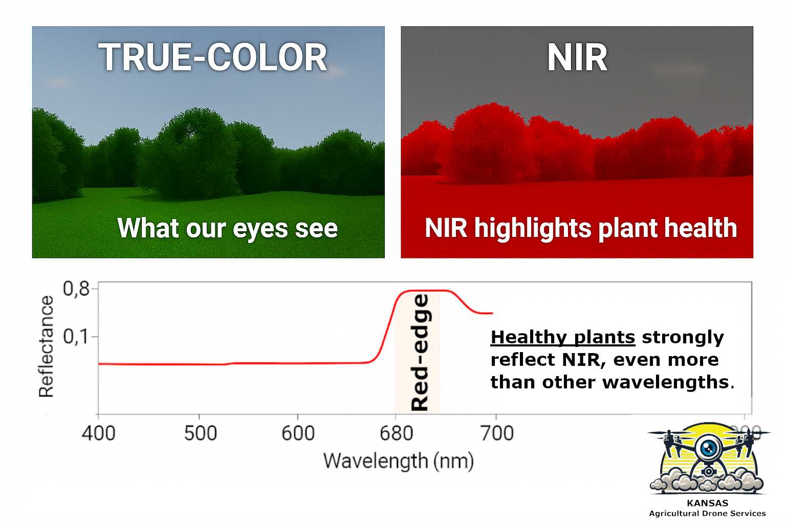
Near-infrared (NIR) sits just above red-edge, between 750 – 2500 nanometers. Plants reflect near‑infrared light very strongly when they’re healthy. When they’re stressed—whether from drought, nitrogen shortage, compaction, disease, or pests—the amount of NIR reflection drops.
The human eye can’t see NIR at all, but a multispectral camera can capture it with precision. Because we can’t see these wavelengths naturally, we use false color images to visualize them. That means assigning the invisible channels to visible colors so we can interpret what’s happening.
Here are the red-edge and near-infrared channels captured during the same scouting mission illustrated above.


Why Drone Crop Scouting Matters to Farmers
When you combine digital photography, aerial scouting, and multispectral drone imaging, a farmer receives powerful abilities that may help to understand crop health in new ways, and which simply aren’t possible from the ground.
Here’s what farmers gain:
1. Early Detection of Stress
Multispectral images reveal subtle changes in plant health long before the crop shows visible symptoms. That means earlier fungicide decisions, earlier nutrient corrections, and earlier irrigation adjustments.
2. Spot‑Specific Scouting
Instead of walking the whole field hoping to stumble across a problem, you can fly a drone, identify the exact trouble spots, and walk straight to them. That saves time, fuel, and labor.
3. Better Input Efficiency
When you know exactly where the crop is struggling, you can apply fertilizer, fungicide, or herbicide only where it’s needed. That reduces waste and increases ROI. I’m not certain why spot-application has not caught on more.
4. Tracking Crop Progress Over Time
Digital photography gives you a record of the field at every growth stage. You can compare emergence, canopy development, and stress patterns year over year.
5. Seeing What the Human Eye Can’t
The biggest advantage of multispectral imaging is simple: It reveals what’s invisible. You’re not guessing anymore—you’re measuring.
Future posts will cover extensions to digital photography for agriculture, including how to make sense of the images, the equipment necessary for drone crop-scouting, a review of vegetation indexes, how to create vegetation indexes from multispectral images, and how to perform “green on green” weed scouting with a simpler true-color RGB drone. Stay tuned!